Where are the Australian bushfires burning? Will I be in their way? Over an Australian summer, the majority of people can answer the first question with a rough degree of confidence thanks to the mapping and forecasting products produced by the fire services of the eight states and territories of Australia, and a myriad of related agencies.
But being able to answer the second and more important question, can be no more than gut feel at times. A gut which needs information to accurately assess a situation, turn that assessment into a decision, and subsequently into effective action. A lot has to go right…
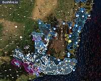
Some states in Australia have great apps available which map fires on your phone and they send alerts. If you're lucky there is a separate app which includes blocked/closed roads and traffic information. And of course we all have many weather apps which gives us important insight into the wind conditions–where the fire is heading. We combine this with local knowledge and past experiences. This app ecosystem works better today than it has ever done, but never holiday in another state.
We all know how chaotic this can be, especially for something as important as keeping our families and community safe. What started off as a hacked together website for friends to combine bushfire warnings and closed roads for one of the eight states and territories, it has been shared thousands of times.
I feared for my bank account, but after some fairly frantic "cache everything" work, our satellite imagery provider–MapBox–has kindly provided its support, so attention has been directed to where it's needed. There's now data from three other state's fires, wind conditions, fire fighting aircraft and much more to come in response to community feedback, such as warnings for the remaining states and territories along with overlays for things like hotspots/ground surface temperature anomalies.
However, even with all of this existing information put together there's a significant challenge in the initial detection and ongoing monitoring of bushfires in Australia. We have sophisticated satellite sensors and algorithms to detect anomalies, but satellite periods are typically measured in multi day windows. Obviously this gives new bushfire the upper hand as it can easily spread unchecked. Maybe Australia needs to invest in space a little more?
From the positive response, it certainly feels like there's considerable demand for an app which combines as much information as possible into a single usable view to support the large Australian community, no matter which state you are physically in. Maybe this app will help you figure out if you might be in bushfire's way, but there's a long way to go and while technology certainly doesn't have all of the answers, it can certainly help if we truly leverage it and include it in our future plans.
If you're keen, checkout https://bushfire.io. I'd love any ideas you might have!
