A computer-generated recreation of the seismic pounding taken by San Francisco during the devastating 1906 earthquake was launched online Thursday by the US Geological Survey.
Simulations of earth shaking and tectonic plate shifting were put on display along with images of the damage inflicted on the city by the historic temblor that struck one hundred years ago this month.
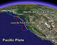
The virtual tour used geographic mapping by Google Earth to start with a view from space and swoop in on the 300-mile (483-kilometer) rupture along the San Andreas Fault that caused the 1906 earthquake.
"You watch it on a screen and zoom along on a map," said Leslie Gordon of the survey. "We are using the centennial to remind people they live in earthquake country and need to be prepared."
"Some people can be told, or read it and it doesn't sink in until they visualize it."
There was a 62 percent chance of another major earthquake occurring in the San Francisco area within the next 30 years, according to Gordon.
"It is all lessons learned for today," Gordon said of the presentation viewable online
