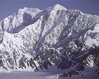
Canada's tallest mountain had a growth spurt in the past 15 years and may still be growing, according to an aerial survey of ice-covered Mount Logan on the Yukon-Alaska border.
A University of Alaska team of scientists recently used a laser altimeter to peg Canada's geographic zenith at 5,966 meters (19,574 feet), seven meters (23 feet) higher than the official height of 5,959 meters (19,551 feet) determined in 1992 by the Geological Survey of Canada.
The variation could be the result of errors in early surveying, a thickening snow pack or tectonic uplift, they said in a research article on the school's website.
"Right now, the summit is all snow and ice," commented surveyor Michael Schmidt in the article.
"There could have been that much snow accumulation since then, but … I'd be really surprised if there was seven meters of snow accumulation in that time span," he said.
Chris Larsen of the University of Alaska's Geophysical Institute, however, speculated that warmer, wetter weather linked to global warming resulted in higher than average snowfalls on area mountaintops.
"That could be what's going on with Alaska, and the high peaks would be a perfect place to measure it," he said.
Mount Logan is not only Canada's tallest peak, it is also the world's largest mountain with a 20-kilometer (12.5-mile) long plateau and massive footprint in the St. Elias-Wrangell mountain range.
The mountain was named for 19th-century scientist William Logan, founder of the Geological Survey of Canada, and is the centerpiece of Kluane National Park, a bi-national UNESCO World Heritage site on the Alaska-Yukon border.
Its true height has been debated for almost a century, since it was first surveyed in 1913.
Share This Article With Planet Earth
