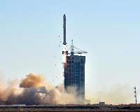
China launched a pair of 0.5-meter high-resolution remote sensing satellites Tuesday from the Taiyuan Satellite Launch Center in north China's Shanxi Province.
The satellites, SuperView-1 03/04, blasted off at 11:24 a.m. Beijing time on the back of a Long March 2D rocket, according to the center.
The mission aims to promote the country's commercial use of high-resolution remote sensing satellites.
The satellites, which are able to provide commercial images at 0.5-meter resolution, are expected to offer remote sensing data to customers worldwide and provide services to land and resource surveys, mapping, environmental monitoring, finance and insurance as well as the Internet industry.
The satellites were developed by China Aerospace Science and Technology Corporation.
It is the second launch of the corporation's commercial remote sensing satellites, followed by the launching of SuperView-1 01/02 in December 2016.
Earth passes perigee, its closest point to the sun
Early Wednesday morning, Earth passed its closest point to the sun, a portion of its orbit known as perihelion.
During perihelion, Earth is 91.6 million miles from the sun. At the most distant portion of its orbit, the aphelion, Earth is 94.5 million miles from the sun.
The Earth's path isn't perfectly circular – it is oblong. Astronomically speaking, however, the 3-million-mile … read more
