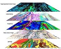
CSIRO and the Geological Survey of Queensland are combining to conduct a series of workshops on hyperspectral mapping. The workshops follow the successful release in July of a set of over 30 maps based on airborne hyperspectral data and satellite imagery covering the greater Mount Isa region.
To be conducted in Brisbane and Townsville in late November and the fifth in the 'Digging Deeper' series, the workshops will offer exploration geoscientists an introduction to hyperspectral mineral mapping theory, a presentation on the recently completed hyperspectral maps and a hands on computer workshop featuring real case histories.
"Hyperspectral imaging and analysis is becoming an increasingly important exploration technique and this is an exciting opportunity for geoscientists to learn more about using it in areas such as Mount Isa," CSIRO's Dr Tom Cudahy said.
Mr Mal Jones from the Geological Survey of Queensland added that the objective of the workshops is to demonstrate the benefits of airborne hyperspectral mineral mapping data as part of the Queensland Government's Smart Exploration Program.
"In collaboration with CSIRO, we will show how the data can be applied effectively by exploration geoscientists to help them map basement and cover materials and areas of potential economic interest," he said.
The Mount Isa area maps were produced as part of the Next Generation Mineral Mapping project of the Minerals Down Under National Research Flagship.
The Predictive Mineral Discovery Cooperative Research Centre (pmd CRC) and the CRC for Landscape Environment and Mineral Exploration (CRC LEME) helped to interpret the significance of the maps. Geoscience Australia collaborated with the CSIRO-Geological Survey of Queensland team on how best to process and use Advanced Spaceborne Thermal Emission and Reflective Radiometer (ASTER) multispectral data. Other collaborators include HyVista Corporation and the James Cook University, with funding from the Smart Exploration program.
