ESA satellites will be providing scientists from 60 countries with data covering Earth's polar regions for the International Polar Year, which runs from 2007 to 2008. During that period, ESA will provide access to Earth observation data free of charge to selected projects covering the Arctic and Antarctic regions.
Data, as well as the exploitation of historical archives, from the following missions will be made available: ESA's Envisat, ERS 1 and -2, GOCE and SMOS (when available) and Third Party Missions including Japan's ALOS and the French Space Agency's (CNES) Spot-4.
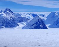
Having access to near-continuous satellite data of these regions over long periods of time will be important for scientists to identify and analyze long-term climatic trends and changes, the space agency said in a news release.
ESA said it will provide current and historical data, dating back 15 years, from its ERS-1, ERS-2 and Envisat satellites, as well as data collected from a number of non-ESA satellites.
Since their advent, satellites have contributed to a greater understanding of polar regions. They have helped identify the strong links these regions have with Earth's terrestrial, ocean and atmospheric processes and made important observations.
For example, within days of its launch in 2002, ESA's Envisat captured the disintegration of the Larsen-B ice shelf in Antarctica, surprising scientists because of the rapid rate at which the shelf broke apart.
The International Polar Year aims to enhance international collaboration in polar region research and monitoring. Its organizers aim to link researchers across different fields to address questions and issues lying beyond the scope of individual disciplines.
IPY organizers ensure that data collected under its auspices are made available in an open and timely manner and intensify the recovery of relevant historical information and ensure it is made openly available.
IPY has been celebrated three times over the last 125 years – in 1882-1883, 1932-1933 and 1957-1958. Scientific and exploring programs borne out of each IPY have led to scientific advancements, new discoveries and an increased understanding of many geophysical phenomena that influence the Earth's global systems.
Past IPY accomplishments include the establishment of the first year-round research station inland from the Antarctic coast, the addition of more Antarctic stations, the initiation of the global space age and the ratification of the Antarctic Treaty in 1961, which suspended all territorial claims and designated the continent as a place for peace and science.
"Many researchers use satellite data as part of their daily activities," said David Carlson, director of the International Program Office for the Polar Year.
"During IPY those researchers will push to extract more and more information from the satellites, particularly to understand recent and current distributions of snow and ice," Carlson said. "We will use every form of satellite data – passive visual, active microwave, and even sensitive gravity measurements – to understand changes in the global ice sheets."
