GeoEye announced Wednesday the National Geospatial-Intelligence Agency Stereo Airfield Collection program has awarded the company $3.7 million to image 365 airfields and produce Airport Mapping Databases over a 12-month period.
GeoEye will deliver IKONOS stereo imagery and perform three-dimensional airport feature extraction services in accordance with NGA specifications.
This is the NGA's third and largest Airport Mapping Database award to GeoEye, following two prior awards for three airfields in 2004 and 15 airfields in 2005. The new award takes effect immediately.
GeoEye is now the world's largest developer of airport geospatial information support, terrain and obstacle databases with several hundred airfields mapped to date.
"We are a leader in providing airport geospatial solutions to key customers like the NGA and the USAF at the best price and with the best performance in the industry," said Matt O'Connell, GeoEye's president and chief executive officer.
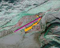
An Airport Mapping Database contains significant features of an airport such as runways, taxiways, buildings, obstacles and terrain surrounding an airfield. This information supports the safe movement of aircraft and helicopters on runways and taxiways.
Such products also can be used to support training, mission or contingency planning and visual simulations for ordinary operations or crisis situations.
GeoEye is uniquely positioned to fulfill this contract for North American and international airfields by virtue of its IKONOS satellite's ability to generate a three-dimensional image from stereo data collected during a single orbital pass. The result is a three-dimensional map-accurate image of an airport that can be quickly and cost effectively acquired.
"We are also completing a project for 13 commercial airports in South America for the Latin American Civil Aviation Commission," said Dejan Damjanovic, GeoEye's program manager for airfield and harbor mapping.
As GeoEye's single biggest customer, the NGA has awarded the company more than $50 million in 2006 for imagery and services.
GeoEye is currently building its next-generation commercial satellite imaging system, GeoEye-1, which will provide a ground resolution of 0.41-meter panchromatic and 1.65-meter multispectral or color imagery. The launch of GeoEye-1 is slated for early 2007 from the Vandenberg Air Force Base in California.
