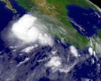
Hurricane John Thursday barreled on a parallel track to Mexico's Pacific shoreline and targeted the tourist-packed Baja California peninsula. The storm was projected to reach the tourist resort of Cabo San Lucas on Friday after drenching coastal areas of the mainland's Pacific coast, according to the Miami-based National Hurricane Center (NHC.)
Puerto Vallarta, another favorite tourist destination, was also dangerously close to the storm's projected path.
The NHC projections indicated the storm would not hit the coast before it slams into the Baja California peninsula, though forecasters pointed out that a slight deviation from the projected track could take it inland.
Even if the coastline does not get slammed with the full power of the storm, it is likely to be hit by winds up to hurricane force, the NHC said.
There was good news as the hurricane gradually lost some of its power, decreasing to category two, from a a dangerous four on the five-level Saffir Simpson intensity scale. But NHC forecasters said it could strengthen again before reaching Baja California.
The forecasters also warned that rainfall could cause "life-threatening flash floods and mudslides" while "large and dangerous battering waves" should be expected in areas close to the hurricane's path.
A US Air Force reconnaissance aircraft which flew into the hurricane measured its maximum sustained winds at 165 kilometers (105 miles) per hour at 2100 GMT, when the storm was located 385 kilometers (240 miles) southeast of the southern tip of Baja California.
Some 1,000 kilometers, (600 miles) further west, the weaker Hurricane Kristy was blowing over over open Pacific waters and not threatening land, the NHC said.
