The first high resolution images of the Earth transmitted by TopSat, the micro-satellite designed and built by a QinetiQ-led consortium of British firms, have been received at QinetiQ's West Freugh ground station.
The low cost Earth observation satellite is six weeks into its mission following a successful launch from the Plesetsk cosmodrome in Northern Russia on 27 October 2005.
TopSat is a major step forward in the affordability of space missions, providing 2.8 metre resolution images at a much reduced cost compared to larger satellites. Typically, current generation imaging satellites with comparable performance cost over five times more than TopSat.
TopSat also has the best resolution per mass of any imaging satellite currently available so has a wide range of applications. These include mineral and petroleum exploration, forestry, flood monitoring and combating maritime oil pollution.
The images produced by TopSat are delivered in near-real time, enhancing its ability to support disaster relief operations in the event of landslides, earthquakes and other emergencies. Images can also be delivered to customers in situ via QinetiQ's fully mobile data ground station (RAPIDS).
TopSat was designed and built by a consortium of British companies led by QinetiQ, whose role includes systems design and technical authority, provision of the major payload electronics units, operations management and ground segment.
Surrey Satellite Technology Ltd (SSTL) developed and manufactured the satellite platform and was responsible for the integration of the payload testing, arranging the launch at Cosmos, and commissioning the satellite platform in orbit. Rutherford Appleton Laboratory (RAL) designed and manufactured the camera and Infoterra is marketing TopSat data products.
Speaking on behalf of the consortium, Andrew Rogoyski, managing director of QinetiQ's space division said: "With improved performance and falling costs we are entering a very exciting era for small satellites. We genuinely believe that low cost ownership of space platforms is becoming a reality."
The programme has been jointly funded by the British National Space Centre (BNSC) and the UK Ministry of Defence at a mission cost below ¿14m.
Lord Sainsbury, minister with responsibility for the BNSC and UK space policy at the Department of Trade and Industry said: "The first images received from TopSat mark the latest chapter in a genuine British success story. They represent the culmination of five years' work and are an example of what can be achieved when four British companies work together.
"The project is also a fine example of the benefit of the BNSC partnership in fostering collaboration between Government departments, to stimulate industrial capability and capacity."
Professor Roy Anderson, chief scientific adviser to the Ministry of Defence said: "The development of TopSat is at the cutting edge of scientific innovation and reflects the UK's leading research capability in this highly competitive field. I am delighted that the MOD and the BNSC have worked together successfully to fund a project that will bring benefit to both civil and military users all over the world."
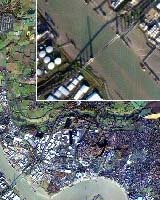
The image
The satellite image was acquired at 10.03am on Wednesday 7 December 2005. The morning traffic is clearly visible on the Queen Elizabeth II Bridge at the Dartford Crossing, UK. The image shows Thurrock and the Lakeside shopping centre in Essex to the north, and Greenhithe and the Bluewater shopping centre in Kent to the south.
Ships are visible underway from the Thames estuary and alongside at the Tilbury docks to the east. TopSat imagery at nadir has a nominal 2.8m resolution in black and white and 5.7m in colour. These images are not full quality as they are JPEG format to allow the wide distribution. A full range of images are available from the QinetiQ press office.
The technology
