| . |  |
. |
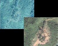
Washington (AFP) Sept 28, 2007 Satellite pictures show ethnic minority Karen villages burnt to the ground in Myanmar, US researchers said, unveiling images taken months before the military regime's latest crackdown on dissents. Patches of scorched earth corresponding to settlements reportedly destroyed are visible in the high-definition photographs taken by satellites zooming in on the secretive state in late April and analyzed by the Washington-based American Association for the Advancement of Science (AAAS). Now the group has trained the satellites on Myanmar's main cities to try and peer through the clouds and see military deployments amid the current unrest, as the crackdown on pro-democracy protests led by monks has turned bloody. In Karen areas of eastern Myanmar, the group used three commercial satellites to focus on 31 "attack sites" of reported rights violations from mid-2006 to early 2007, AAAS project director Lars Bromley told reporters Friday. In one picture, a satellite spotted foundations and fence lines with all the structures gone, where a village had stood two years earlier. The area photographed was the site of a reported military raid on April 22, on Karen villagers accused by the regime of supporting armed rebels. Bromley estimated a dozen people were killed there and the rest fled. Fast-growing vegetation had already begun to cover some of the sites. "We saw quite extensive evidence of possible forced relocation," Bromley said in a telephone conference, citing pictures of other villages that have sprung up around a military camp, amid a visibly expanded military presence. "We are trying to send a message to the military junta that we are watching from the sky ... We are warning them not to continue" repression, said Aung Din, policy director of the Washington-based US Campaign for Burma (Myanmar's former name). "By showing this evidence, satellite imagery, we are expecting that we can persuade China" to join international opposition to the junta's crackdown, he added. China and Russia have blocked UN Security Resolutions aimed at condemning the regime. A minority rebel group, the Karen National Union, has battled Myanmar's rulers for 57 years in one of the world's longest-running insurgencies, but Aung Din insisted those killed in the villages were ordinary villagers. He said 3,000 villages had been destroyed by the military rulers altogether, with 1.5 million Myanmar refugees from various minority groups living in neighboring countries and 500,000 internally displaced people hiding for their lives in its jungles and mountains. The campaigner said 70,000 child soldiers had been forcibly recruited in Myanmar and 2,000 political prisoners were held. The best know is the Nobel Peace Prize winner Aung San Suu Kyi, who has spent years under house arrest. Tactics used by the ruling junta include forcing ethnic minorities to abandon their homes and firing mortars to intimidate those trying to grow crops, said the AAAS, which gathered reports from three human rights groups on the ground. It released the images as reports from Myanmar of a deadly crackdown on pro-democracy protestors in the country this week sparked condemnation and calls from world leaders for an end to the violence. Bromley said that when the latest unrest broke out, AAAS arranged to capture more satellite pictures of the main cities. Security forces on Friday clamped down on protests in Myanmar's two biggest cities, Yangon and Mandalay, firing warning shots and using baton charges in the third day of the crackdown that has left at least 13 people dead. "Since the situation in Burma is getting worse under the military junta, we are trying to call for the international community to act quickly and effectively," Aung Din said. AAAS had previously carried out similar studies to highlight abuses in Zimbabwe and Darfur in western Sudan. Community Email This Article Comment On This Article Related Links Military Space News at SpaceWar.com
 Redondo Beach CA (SPX) Jul 31, 2007
Northrop Grumman, in conjunction with the government's tri-agency NPOESS Integrated Program Office, has completed the restructure of the National Polar-orbiting Operational Environmental Satellite System (NPOESS). This restructure represents a rigorous year-long effort to re-plan virtually every aspect of the NPOESS program following its certification and restructuring through the Nunn McCurdy process in 2006. The plan details the development and delivery of the system through initial production in the next decade. |
|
| The content herein, unless otherwise known to be public domain, are Copyright 1995-2006 - SpaceDaily.AFP and UPI Wire Stories are copyright Agence France-Presse and United Press International. ESA PortalReports are copyright European Space Agency. All NASA sourced material is public domain. Additionalcopyrights may apply in whole or part to other bona fide parties. Advertising does not imply endorsement,agreement or approval of any opinions, statements or information provided by SpaceDaily on any Web page published or hosted by SpaceDaily. Privacy Statement |