A team of international scientists will soon travel to the tsunami-ravaged Indonesian province of Aceh to map out the submarine destruction caused by deadly tidal waves, the Norwegian Institute of Marine Research said on Tuesday.
Using two ships, one equipped with a miniature submarine, about 35 Indonesian, Norwegian, Russian and Thai researchers will study the ocean floor at depths of between 20 and 100 meters (66 and 328 feet), with a special focus on reefs and fish stocks.
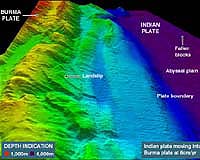
"Indonesia has been hard-hit and everything indicates that the sea bed, and especially the barrier reefs, have been affected," by last December's Indian Ocean tsunami, head of the Norwegian-led expedition Jan Helge Fossaa told AFP.
"The results of our cartography will be useful for the Indonesian authorities in defining their future policies concerning fishing and possibly rebuilding their (fishing) fleet," he added.
The expedition, which will take place between July 24 and August 18, is expected to cost about 10 million kroner (1.5 million dollars, 1.3 million euros) and will be financed by the Norwegian government and the World Bank.
The western Indonesian province of Aceh was the area hardest hit by the December 26 tsunami, which left 131,000 people dead in that area alone.
In all, some 215,000 people in coastal areas perished in the earthquake and ensuing tidal waves.
