People will soon be able to find out how vulnerable their own local area is to global warming, thanks to new techniques developed by members of the STARDEX project.
The STARDEX project's seven European research teams, led by the University of East Anglia, narrowed down evidence of changing weather patterns to predict the occurrence of floods, heat waves and drought on even smaller regions across the UK and Europe.
And the new method of analysis could help governments prepare for or even prevent a predicted increase in flooding by up to 50 per cent in certain areas of the River Rhine and by 25 per cent in areas such as north-west England by the end of the century.
The European Union-funded project brought together expertise from across Europe to study the complex impacts of regional climate change.
Its report is published as United Nations leaders gather in Montreal, Canada, next week (November 28 to December 9) for the UN climate change conference to discuss the Kyoto Protocol and the impact of climate change.
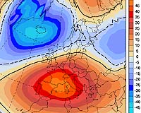
In the past climate change analysts have only been able to predict the impact of global warming on temperature and rainfall by examining the output of global climate models every 250 km. This large scale analysis meant that temperature and rainfall trends were averaged out resulting in generalizations about the impact of climate change on local regions.
The STARDEX project was the first European-wide study to apply a large variety of the best statistical and modeling techniques to determine the likely impact of climate change at specific sites. Termed downscaling, these techniques give a much better idea of possible changes in temperature and rainfall at the local scale.
The research groups used observed station data for six case study regions across Europe and a specially constructed dataset of 491 European wide daily station records to analyse climate trends over the past 40 years and likely changes at the end of the 21st century.
The UK based teams' report reveals that by 2100 south-east and north-west England will see up to 25 per cent increase in heavy rainfall during five-day periods in winter -which leads to flooding – and up to 25 per cent decrease in rainfall in summer causing drought.
And these new statistics will help determine the chance of extreme weather in certain areas, taking into account local topography, enabling local populations to prepare for and even prevent disasters such as flooding and drought. At present at least five million people live in areas with a high risk of flooding in England and Wales.
The STARDEX report concludes that there is a need to develop even more efficient techniques to enable scientists to predict local impact. This work has already started as part of the ENSEMBLES integrated project which aims to further understand and reduce uncertainties in climate change predictions.
Dr Clare Goodess, of UEA's Climatic Research Unit and STARDEX project coordinator, said: "The STARDEX projections quantify the changes in the frequency and magnitude of extreme weather events that can be expected in individual European cities and regions if no action is taken to reduce human-induced global warming. The prospect of increased winter flooding will be alarming to inhabitants of cities such as Carlisle in NW England and Cologne in Germany with recent personal experience of the damage and disruption that such events cause."
"Although more research is needed to increase our confidence in projections of summer rainfall, we are sufficiently confident in the projected increased risks of flooding, drought and heatwaves to believe that the need for action on climate change is more urgent than ever before," added Dr Goodess.
European Case Studies
