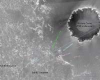
This image from the Mars Orbiter Camera aboard the Mars Global Surveyor shows Opportunity's position as it approaches Beagle crater on the way to Victoria crater. North is to the left. Opportunity's locations at Martian mission days, or sols, 804 (April 29) and 855 (June 20) are marked, as are the left and right edges of the rim of Victoria from the rover's point of view.
The labeled promontory is a bright spot mission scientists at NASA's Jet Propulsion Laboratory originally thought was an outcrop on the far side of the crater, based on a measurement taken on sol 804. But comparing the azimuth angle of this feature in the sol 855 panorama and the angle of the same feature in the sol 804 panorama (a process known as triangulation) revealed this outcrop must be on the near rim of the crater.
Marked in salmon are two small craters beyond Beagle crater on the dark annulus, or ring, around Victoria.
Victoria is 730 meters to 750 meters (nearly half a mile) in diameter, about six times wider than Endurance crater, where Opportunity spent several months in 2004 examining rock layers affected by ancient water.
The image is an uncalibrated version the rover team uses for planning. It has been re-projected and stretched in some places and is not used for scientific purposes.
